The Three Peaks, Yorkshire

The three peaks, Yorkshire are Pen-y-Ghent (2267ft), Ingleborough (2372ft) and Whernside (2388ft); small mountains in the Yorkshire Dales National Park, which is an outstandingly beautiful area of England filled with wildlife habitat of national and international importance. It includes areas of limestone woodland, heather moorland, raised bog and wildflower rich meadows. You might see species such as the Northern brown argus butterfly, peregrine falcons, yellow wagtails, cloudberry and common rock rose.
The Yorkshire three peaks are a popular walking challenge, which has the advantage over the national three peak challenge of there not being any driving between the peaks. The whole route is a circular walk and you can even camp near the starting point in Horton in Ribblesdale, or stay in a B+B and give yourself a car free day.
It is geologically exciting too with distinctive valleys, known as dales, limestone pavement and crags and potholes leading to extensive cave systems.
The strong cultural heritage is interesting with archaeological remains from the Palaeolithic onward, stone barns and the dry stone walls of working farms,contributing to the character of the area, remains of small industries such as lead mines and the incomparable Settle to Carlisle railway.

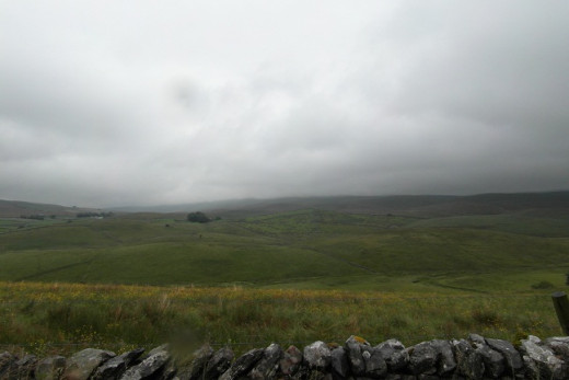
Yorkshire Dale's Scenery
Click thumbnail to view full-size


Three Peaks Record
Set by a fell runner in 1979, the record is two hours, 29 minutes and 53 seconds!
The Yorkshire Three Peaks Challenge
The official three peaks challenge is a 24.5 mile circular route starting and finishing in Horton in Ribblesdale. It includes the summits of the three peaks. The aim is to complete it in under twelve hours.
The Three Peaks Walk with Dogs
The walk is fairly challenging for the average family dog so make sure you include your pet in your fitness preparation. Ideally complete at least one shorter training walk with them over similar terrain.
Make sure you can control your dog whilst walking through livestock and walking downhill on slippery and rocky terrain - you don't want to be pulled over and wrench or break and ankle!
It is not suitable for giant breeds because there are some difficult stiles which you may need to lift a large dog over and the rocky and precipitous terrain is unlikely to suit them.
If you are taking a small or short legged dog be prepared to carry them over boggy areas and provide help up and down steep rocky slopes.

Do take easily digestible snacks for your dog and some water, although there are plenty of clean streams they can drink from too. A spare slip lead would be handy lest the dog lead or collar breaks.
Don't allow your dog to disturb ground nesting birds or run amongst sheep. It is a good idea to keep dogs on the lead.
An Account of the Yorkshire Three Peaks Walk by completed by Anna and Rachel (humans) and Bob, Bruno and Miele (dogs) on 16th July 2012.
Subtitled: Soggy, Foggy, Boggy and Doggy
This account does not aim to serve as a route map or instruction manual for the three peaks walk, rather I hope it gives you a good flavour of the experience in quite testing conditions, so that you can decide for yourself whether you could realistically consider taking the walk, would rather tackle one peak in a day (each is a good walk by themselves) or just prefer to enjoy our experience from the comfort of your armchair.
Summary (it wasn’t summery!)
Humans walking in aid of Hear and Now a voluntary organisation being set up to provide free counselling to folk in Burnley. Dogs walking in aid of RSPCA East Lancashire branch (former home of Bob).
Map reader and route master – Anna
Reporter and photographer – Rachel (AKA Nettlemere)
Dogs - Miele the golden retriever, Bruno labrador and Bob the terrier
Weather forecast was intermittent rain throughout the day. Full Route distance 23 – 26 miles depending on variation. Our Mileage 22+
Preparation – over the course of 2 months we all prepared for the walk by regularly going up Pendle Hill near our homes in Lancashire and putting in a fair bit of mileage on foot. For example I did a couple of five hour hikes with the dogs over similar terrain to what I expected from the three peaks. Human fitness on the day was reasonable but room for improvement. Dog fitness – Miele youthful retriever and full of beans, Bruno 11 year old Labrador, plenty of stamina, Bob 4 year old short legged terrier who doesn’t like rain; he was our biggest query as to ability to complete the course. Hence back up car sited at base of second peak in case any of us were injured or flagging markedly.
Other walkers on the day: We met three groups of men – a three, two and a 1 doing the 3 Peaks. We suspect the 3 didn’t complete, but the 2 and 1 did. We met 2 women who had walked from Stainforth up Ingleborough and were going a couple more miles. 1 fell runner coming towards us – we didn’t enquire as to his route. A couple of groups of Duke of Edinbrough students not doing the 3 Peaks. There were no other dogs.
Route taken. Horton in Ribblesdale start. Up Pen-Y-Ghent (PYG) across moors to Ribblehead viaduct (Ingleborough tantalisingly in view on occasion). Up Whernside, up Ingleborough. Return to car.
")
Pen-y-Ghent
7.45am: We start at Horton in Ribblesdale. It is overcast with PYG summit in cloud. Overall visibility is reasonable and the route straightforward to follow, but very steep and quite a scramble in places. With only little legs, Bob needed a brief lift up rocks too high to jump up. We achieve PYG summit (P1) in good heart. Rain started as we made our way down.
")
")
9.45 Advised through internet forums to avoid an especially boggy patch, we detoured a little taking a slightly longer route. We crossed the fast flowing stream (P2). I fell in – now sodden to the waist. We hit the moor and the cloud has come down. Visibility down to 20ft in places and the rain is persistent (P3). It is impossible to see where the path is due to boggy conditions. Three men attempting the route with a Sat Nav are quite disorientated and heading in totally the wrong direction. Our map and compass wins the day. I get knee deep in mud. Bob sodden and shivery needs carrying for a mile or 2.
We make it across the moor to a clear track which proves to be the one we were aiming for. It is still raining but there are tantalising glimpses of Ingleborough which we pass quite closely (P4,5,6). The view back to the moors shows how low the cloud was (P7). It is 12.30pm and we suspect we may only complete two of the 3 peaks at this stage.Miele and Bruno excepted, we’re somewhat disheartened.
")


")


")
Ribblehead Viaduct
Hurray – we can see the Ribblehead viaduct (P8,9) which is the bottom of Whernside. The Ribblehead viaduct is a phenomenal feat of engineering and part of the world famous Settle to Carlisle line. Construction of the line began in 1869 and took seven years to complete. We can understand why having covered some of the terrain on foot.
We can’t see Whernside due to cloud. I get excited because it appears to be brightening back towards PYG (P10) although the rain continues. We pass the manned Blea Moor signal box – a great job if you’re a bit unsociable and then cross the rather lovely aquaduct (P12) and pass the waterfall (P13). Intermittently the rain stops briefly and I imagine that thinner areas of cloud are about to break and reveal sunshine. Disappointingly, no glimmer of sunshine ever gets to us.
")
")
")
")
")
")
")
")
")
")
")
")
")
")
")
")
Whernside
The walk up Whernside is a clear path and long rather than steep, but I flag. Anna maintains team morale. For most of the way the view is cloud (P14). We reach the summit of Whernside (P15) On the way down Anna flags a little and I maintain team morale. Bob is gritting his teeth and buckling down in spite of the weather. Bruno and Miele are full of beans. We can see Ingleborough ahead (P16) – the final peak, but should we do it?
We reach our backup car. Body parts are holding up and all dogs are still game. It is 5pm so time isn’t an issue, but visibility is, despite a distant patch of sunshine (P17). We discuss whether it would be safe to continue.
")
")
")
Ingleborough
Knowing we have the backup car and can turn back if necessary, we bite the bullet and head up Ingleborough with fortitude. Ingleborough is steady for a stretch and then steep. My pace slows to less than 1 mile an hour and I run out of fortitude. Bob requires some boosts to get up the rocks. Anna maintains team morale. Miele decides it’s time for a game with a plastic bottle. Is her energy endless?
We get to the top of Ingleborough. The rain has stopped. The only problem is that visibility is so poor that we can’t see the Triangulation point, which is the official summit, despite wandering around in a moderately intelligent fashion. Hence P18 and 19 are us by one of the cairns at the approximate summit. (There is nowhere to place the camera for a joint shot on time delay.) P20 is the view from Ingleborough.
We also can’t tell where the path down towards Horton in Ribblesdale begins so make the sensible decision to return the way we came. The descent is particularly precarious and hard to judge where to safely place our feet. Bob finds it wearisome and a bit nerve-wracking, but continues bravely. Anna slips; one foot in the air, the other sliding downhill for 4ft. Amazingly she keeps her balance, however loses a little morale. I am making random huffs, puff, grunts and groans, but take up the morale maintaining baton.
")
")
")
")
")
")
")
")
Would you do the Three Peaks Walk?
At last we are near the bottom of Ingleborough and so is the cloud cover as we look back (P21). Surprisingly for about a minute ahead PYG is glimpsed in a single patch of sunshine (P22). I look back towards Ingleborough again and that cloud is chasing us (P23). Ahead PYG is again obscured. With just a mile to go it is a race to make the backup car before the cloud reaches us.
8.45pm, thirteen hours after we started walking we reach the backup car for a second time, having reached the summit of each mountain. Gladly shedding rucksacks we heft weary dogs into the car. We are all sodden, but it was nice to beat that final cloud and not get rained on again.
Distance wise we saved two or three miles returning the way we did, but I hope you’ll agree that we completed the Yorkshire three Peaks to a satisfactory standard given the conditions.
I should add that on a clear day the views are far reaching, varied and stunning. Even on our walk visual highlights included distant shafts of sunlight illuminating Pen-y-Ghent and lovely Ribblehead aqueduct. Please don't let our wet and cloudy walk put you off from visiting the Yorkshire three peaks to enjoy the scenery for yourself.


